

A spare pair of AAs can be more useful than a power bank when the route runs past the last socket.
On day four of a wet traverse, a dead internal battery is not merely inconvenient: it can mean rationing navigation, track logging, and backlight use. AA-powered handhelds keep the power plan simple—field workers can carry lithium cells for cold, paddlers can seal spares in a dry bag, and hunters or backpackers can replace depleted batteries without waiting beside an outlet.
That flexibility has trade-offs. Long runtimes often come with modest screens, slower redraws, or more basic mapping than premium rechargeable units. Battery chemistry also matters: disposable lithium AAs tend to hold voltage well in cold conditions, while NiMH rechargeables reduce waste but may deliver less runtime. The practical question is not just how long the unit runs, but whether its display, satellite reception, waypoint capacity, and route tools remain usable when weather and fatigue make navigation harder.
- Two AA cells are widely available, but a waterproof spare set matters as much as nominal runtime.
- Color mapping and frequent backlight use typically draw more power than simple breadcrumb navigation.

Match the Handheld to the Trip


Field power is a system, not a feature
AA battery GPS units rely on AA cells, which matter most when a trip outlasts a wall outlet. Power independence helps navigation when outlets vanish and travelers need steady recharging options.
A navigator can leave with one set installed. Carry a compact spare set. Accept cells borrowed from a headlamp, camera, or trail-town shelf. That makes power planning more flexible than a sealed battery pack. But it does not make the receiver more accurate, nor its maps more detailed. Its interface remains just as easy to use.
Overall, planning with spare AA cells supports reliability on trails and trips. This approach keeps you powered without promising new accuracy or faster maps. It helps you stay prepared while using familiar devices. And it remains compatible with most standard charging options.
Cell chemistry changes the result. Alkaline AAs are widely available and sensible for a resupply cache, but their voltage sags under sustained screen, backlight, and GNSS load. Cold weather makes that weakness more apparent. Lithium primary AAs are lighter, retain output better in low temperatures, and store well for emergency spares, making them a strong option for winter or long carries. NiMH rechargeables can be economical across repeated trips and support higher sustained draw well, but need a charging plan and may arrive with less usable cold-weather capacity than lithium cells.
For extended navigation, carry cells in a sealed, labeled case and replace both cells as a matched pair.
A device’s battery gauge is only an estimate, particularly after switching chemistry.
Additionally, screen brightness, map panning, compass use, satellite mode, and interval can consume more runtime than the battery label suggests.
Sharing GPS coordinates with rescuers also depends on a separate communications device, not the handheld receiver alone.
Receiver versus mapping companion
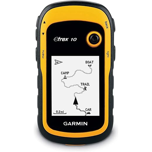
The eTrex 10 is mainly a positioning and waypoint tool.
Its modest monochrome display and basic mapping favor coordinates, tracks, and routes.
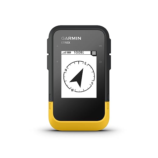
Additionally, the eTrex SE adds a more legible color screen.
It supports a connected-phone workflow, so it can work with offline maps on a phone.
The larger-screen model may be more comfortable for map reading.
However, its rechargeable power system belongs in a different resupply calculation.
For AA battery GPS units, endurance depends on battery choices.
Field readiness means more than an AA compartment. The roundup weighs satellite support, physical controls in gloves or rain, readable screens, track and waypoint handling, map ecosystem, weather resistance, battery-door security, and the practicality of carrying spares. The Travel Bundle can reduce setup friction with included accessories, while the standard SE leaves more freedom to choose cells and mounting around the trip.
For a long carry, lithium AAs are often the reserve set, alkaline cells the easy-to-find resupply option, and NiMH cells the repeat-use choice. Check the manufacturer’s approved battery types and settings: an incorrect chemistry selection can make the remaining-power estimate less useful.
Products are compared as navigation tools operating away from routine charging, not merely by headline runtime.
Battery type, cold-weather behavior, spare-cell logistics, and the consequences of a depleted set are considered.
The review separates coordinate-and-track receivers from devices designed for richer on-device mapping.
Screen readability, controls, satellite reception, weather resistance, and accessory practicality inform field readiness.
Claimed runtime is treated as a starting point; settings, temperature, and map use can materially change it.
Garmin eTrex SE: AA endurance without map-heavy hardware
01
Best for extended trips with reliable multi-GNSS tracking
The eTrex SE is a deliberately lean handheld for trips where spare AA cells matter more than a large mapping screen. Its claimed runtime of up to 168 hours from two AAs makes it unusually practical for long stretches between charging opportunities, while multi-GNSS reception and a digital compass support dependable position work under tree cover or in broken terrain.
The trade-off is that this is chiefly a waypoint, track, and breadcrumb-navigation tool—not a pocket topo-map computer. Before committing to a remote itinerary, load the intended route in Garmin Explore, confirm every turn and bailout waypoint transfers as expected, and inspect the route at the device’s actual 2.2-inch screen scale. Dense junctions, long off-trail legs, and map-dependent decisions may call for a larger-display companion. For a broader comparison of that choice, see GPSMAP 67 and eTrex Solar options for remote routes.
The sunlight-readable display and physical buttons favor wet gloves, cold conditions, and quick one-handed checks. Its IPX7 rating adds reassurance around rain and accidental immersion, but route data should still be retained on a phone, paper map, or another independent device.
- Claimed up to 168 hours on two AA batteries
- Multi-GNSS reception for more resilient position fixes
- Buttons remain usable with gloves and in rain
- Compact, IPX7-rated housing
- Small display limits route-context reading
- No rich on-device topo-map experience
- Route transfer and verification rely on pre-trip setup
- Screen scale can obscure close-spaced decisions
In brief A strong fit for disciplined waypoint-and-track workflows with a robust AA power plan. It is less convincing when safe decisions depend on reading detailed cartography directly on the handheld.
The eTrex SE earns its place through a useful combination of very long claimed AA runtime, multi-GNSS support, and uncomplicated button control. It can be an especially capable primary navigator when routes are built around tracks, waypoints, and deliberate pre-trip verification. Travelers expecting detailed on-device maps to resolve every terrain decision may prefer a larger, more map-oriented handheld.
Best for travelers wanting extra power and protection
This is the familiar eTrex SE packaged for departure-day convenience rather than a different class of navigator. The protective EVA case, wall plug, and 5,000mAh power bank make sense for travelers who prefer a ready-made storage and phone-power kit alongside an AA-powered handheld. Its appeal depends on whether those extras replace items already in the kit.
- Protective travel case included
- Power bank and wall plug included
- Same compact eTrex SE platform
- Wireless connection for Explore app
- No AA charger is listed
- Power bank does not directly run the AA handheld
- Accessories add bulk versus handset alone
- No dedicated mount or lanyard listed
For a first handheld purchase, the included case and USB power kit can make packing less fragmented. Check the accessory list carefully: a power bank and wall plug are not substitutes for spare AA cells or a compatible AA charger. Travelers who already own those items may find the standalone receiver the cleaner comparison.
A straightforward choice for budget-minded outdoor enthusiasts
Garmin eTrex 10: coordinates-first navigation on AA power
The eTrex 10 is a deliberately basic handheld for trips built around waypoints, recorded tracks, grid references, and a known route plan rather than on-device map reading. Its worldwide basemap supplies broad geographic context, while the compact monochrome unit keeps the navigation workflow focused on position and direction. It suits hikers, paddlers, and geocachers who want a dedicated GPS receiver alongside a conventional map-and-compass system.
- Runs on two AAs
- Waypoint and track tools
- High-sensitivity positioning
- IPX7 water resistance
- Paperless geocaching
- No detailed mapping
- Small monochrome screen
- 128 × 160 resolution
- Limited map context
The eTrex 10 handles the essential field-GPS jobs: saving locations, following a breadcrumb track, checking coordinates, and establishing direction from a waypoint. Its 2.2-inch monochrome display and worldwide basemap are not detailed enough for confident terrain interpretation, junction decisions, or off-trail route planning. Carrying a paper topographic map or using a separate mapping source remains important wherever navigation depends on trail detail, contours, land boundaries, or hazards.
Best for a larger sunlight-readable display
This 3.2-inch handheld is the display-first alternative for hikers who find compact AA navigators too cramped for reading contours and waypoint context. Its listing pairs a sunlight-readable, button-operated screen with US topo mapping, 32GB storage, a barometric altimeter, and multi-GNSS reception.
There is an important catch for this roundup: the supplied specifications describe a rechargeable battery, not AA cells. Treat it as a power-bank-supported option unless the exact retail unit, its battery compartment, and its accepted cell types are confirmed before departure.
- 3.2-inch sunlight-readable display
- Physical buttons suit wet use
- Topo map stated in listing
- Compass and barometric altimeter
- Multi-GNSS receiver claimed
- Listed as rechargeable, not AA
- Map coverage and updates unclear
- File-format support unconfirmed
- IP66 is not immersion proofing
A potentially appealing choice where a larger, non-touch display matters more than AA resupply. Before relying on it, confirm the actual battery-door design and AA compatibility, included and downloadable map coverage, GPX/track import and export, firmware-update availability, and the manufacturer’s warranty or repair terms.
Test its buttons with wet gloves and check whether the stated IP66 rating aligns with the expected weather exposure. The listed USB charging and claimed 36-hour runtime make a power bank part of the trip-power plan.
What the Spec Sheet Can Mislead About
Multi-GNSS can improve acquisition and track continuity, but it may draw more power than a basic GPS-only mode.
The eTrex SE’s long claimed runtime depends on settings as well as AA cells. Recording interval, backlight use, compass checks, and satellite mode can matter more than the headline constellation count.
A bigger screen can make map detail easier to read, yet it usually demands more energy and may be harder to shield, operate, or carry.
For a preloaded track, a compact button-operated unit can be quicker to check in rain or gloves. The 3.2-inch alternative makes more sense when on-device map interpretation is central.
A rated housing still relies on a clean seal, correctly seated door, and undamaged gasket.
AA changes introduce dirt, moisture, and rushed handling at the one opening that matters most. Drying the compartment and inspecting the seal before closing reduces avoidable power interruptions.
Phone pairing, syncs, notifications, and sensor links add radio activity and setup complexity.
Wireless transfer can be useful for moving tracks, but a cable or preloaded route avoids relying on a phone battery. External sensors also need their own batteries and pairing reliability.
A waypoint on a screen is not a complete emergency reference. Trip notes can include the datum, coordinate format, zone or hemisphere for UTM, timestamp, and location source—for example, a GPS fix versus an estimated map position.
Before departure, compare one known point across the handheld, map, and companion device. If a position must be relayed, read it back from the written procedure rather than trusting a remembered format. The GPS extends situational awareness; map, compass, and route knowledge preserve it when the electronic workflow breaks.
Frequently Asked Questions
How long do these AA-powered handheld GPS units run on a set of batteries?
Runtime claims vary widely by model. The Garmin eTrex SE claims up to 168 hours on two AA batteries, the eTrex 10 lists roughly 20 hours, and the rechargeable 3.2-inch alternative claims about 36 hours from its internal battery rather than AA cells.
Which AA battery type works best for cold-weather trips?
Lithium primary AAs are lighter and hold voltage better in low temperatures, making them a strong option for winter or long carries. Alkaline AAs are widely available for resupply but their voltage sags under sustained load and cold. NiMH rechargeables can be economical across repeated trips but need a charging plan and may have less usable cold-weather capacity than lithium.
What is the difference between the Garmin eTrex SE and the eTrex 10?
The eTrex SE adds a more legible color screen, multi-GNSS reception, a digital compass, and Explore app connectivity, while the eTrex 10 is a simpler monochrome handheld built around a worldwide basemap, waypoints, tracks, and coordinate checks rather than detailed on-device mapping.
Is the eTrex SE Travel Bundle a different navigator from the standard eTrex SE?
No. The Travel Bundle uses the same eTrex SE platform but adds a protective EVA case, a wall plug, and a 5,000mAh power bank. The power bank is chiefly useful for charging a phone or other USB gear, not for powering the AA-based handheld directly.
Does the 3.2-inch alternative run on AA batteries like the others?
No. Its listing describes a rechargeable battery rather than AA cells, so it depends on USB charging or a power bank instead of the swappable AA batteries used by the eTrex SE and eTrex 10.
Are these handheld GPS units waterproof?
The Garmin eTrex SE and eTrex 10 both carry an IPX7 water-resistance rating. The 3.2-inch alternative is listed at IP66, a different standard focused on dust and water jets rather than temporary immersion.
A practical final pick for longer trips
- For multi-day routes built around tracks, waypoints, and coordinate checks, the Garmin eTrex SE is the strongest fit: it prioritizes replaceable-AA endurance over elaborate on-device mapping.
- Choose the eTrex SE Travel Bundle only when its case, wall plug, and power bank genuinely replace gear already needed; they do not substitute for AA spares.
- The eTrex 10 remains a sensible low-complexity option for basic breadcrumb navigation, while the 3.2-inch alternative merits consideration only after its rechargeable-power and map workflow are confirmed.
Before departure, confirm the exact supported AA chemistry, runtime in the GNSS mode and temperature expected, basemap versus detailed-map capability, and every item actually included. Load and test the intended track, waypoint format, coordinate datum, and offline-map fallback before leaving coverage.
Treat the handheld as one layer in a broader navigation and trip-preparation plan: carry a paper map and compass, preserve a second route copy, and rehearse the workflow used at a confusing junction.
Garmin eTrex® SE, GPS Handheld Navigator | Wireless Connectivity, Multi-GNSS Support, Sunlight Readable Screen
Features
| Compatible with Vehicle Type | Truck |
| Screen Size | 2.16 inches |
| Additional Features | Bluetooth |
| Connectivity Technology | Bluetooth, USB |
| Map Types | North America |
| Audio Output Mode | Digital |
| Battery Average Life | 168 hours |
| Mounting Type | Handheld |
| Resolution | 480 x 272 |
| Operating System | Windows |
| Memory Storage Capacity | 28 MB |
| Display Type | LED |
| Human-Interface Input | Buttons |
| Compatible Devices | Android, iPhone |
| Control Method | Push Button |
| Supported Satellite Navigation System | GPS |
| Connectivity Protocol | Bluetooth |
| Sport Type | Camping & Hiking, Outdoor Lifestyle |
| Item Dimensions L x W x H | 4.8"L x 5.24"W x 2.13"H |
| Item Weight | 5.5 ounces |
| Brand | Garmin |
| Model Name | Garmin eTrex SE |
| Built-In Media | eTrex SE handheld device, documentation |
| Model Year | 2023 |
| UPC | 753759376703 753759305628 |
| Global Trade Identification Number | 00753759305628 |
| Number of Packs | 1 |
| Manufacturer | Garmin |
| Number of Items | 1 |
| Unit Count | 1 Count |
| Item Type Name | Handheld GPS |
| Model Number | 010-02734-00 |
| Mfr Part Number | 010-02734-00 |
| Warranty Description | 1 year limited warranty |
| ASIN | B0BT35C89P |
- The 2.2” high-resolution display is easy to read, even in bright sunlight
- Get long battery life of up to 168 hours in standard mode and up to 1,800 hours in expedition mode with 2 field-replaceable AA batteries (not included)
- Pair with the Garmin Explore app on your compatible smartphone for wireless software updates, trip planning, Active Weather, smart notifications and additional mapping
- Get automatic cache updates from Geocaching Live, including descriptions, logs and hints when paired to the Garmin Explore app on your compatible smartphone
- Multi-GNSS support gives access to multiple global navigation satellite systems (GPS, GLONASS, Galileo, BeiDou and QZSS) to track in more challenging environments than GPS alone
- Plot your bearing with the digital compass, which provides an accurate heading even when stationary
- Hike in any weather with the water-resistant design (rated to IPX7)
Garmin 010-00970-00 eTrex 10 Worldwide Handheld GPS Navigator
Features
| Compatible with Vehicle Type | Car, Truck, Motorcycle, etc. |
| Screen Size | 2.2 inches |
| Additional Features | Paperless Geocaching, Track More Satellites |
| Connectivity Technology | USB |
| Map Types | Australia |
| Audio Output Mode | Digital |
| Battery Average Life | 20 hours |
| Mounting Type | Spine mounting |
| Resolution | 128 x 160 |
| Operating System | Garmin |
| Memory Storage Capacity | 6 MB |
| Touch Screen Type | Resistive |
| Display Type | LCD |
| Human-Interface Input | Buttons |
| Compatible Devices | Touch devices, computers, and generally any device that can use USB connectivity or global map |
| Control Method | Touch |
| Supported Satellite Navigation System | GPS |
| Connectivity Protocol | wired |
| Sport Type | Running |
| Brand | Garmin |
| Model Name | eTrex 10 |
| Built-In Media | eTrex 10, Lanyard, USB cable, Manual |
| Model Year | 2011 |
| UPC | 753759975845 |
| Global Trade Identification Number | 00753759975845 |
| Number of Packs | 1 |
| Manufacturer | Garmin |
| Number of Items | 1 |
| Unit Count | 1 Count |
| Item Type Name | Garmin eTrex 10 Worldwide Handheld GPS Navigator |
| Model Number | 010-00970-00 |
| Mfr Part Number | 0100097000 etrex 10 |
| Warranty Description | 1 year limited |
| ASIN | B00542NV32 |
| Item Dimensions L x W x H | 2.13"L x 1.3"W x 4.06"H |
| Item Weight | 141.7 g |
- Rugged handheld navigator with preloaded worldwide basemap and 2.2 inch monochrome display
- WAAS enabled GPS receiver with HotFix and GLONASS support for fast positioning and a reliable signal
- Waterproof to IPX7 standards for protection against splashes, rain, etc.
- Support for paperless geocaching and Garmin spine mounting accessories. Power with two AA batteries for up to 20 hours of use (best with Polaroid AA batteries)
- See high and low elevation points or store waypoints along a track (start, finish and high/low altitude) to estimate time and distance between points
Garmin eTrex GPS Handheld Navigator | Extra Battery Life, Wireless Connectivity, Multi-GNSS Support, Sunlight Readable Screen
Features
| Compatible with Vehicle Type | Any Vehicle |
| Screen Size | 2.16 inches |
| Additional Features | Waterproof |
| Connectivity Technology | Wireless |
| Map Types | Worldwide |
| Battery Average Life | 28 days |
| Mounting Type | Handheld |
| Resolution | 240 x 320 |
| Touch Screen Type | Capacitive |
| Display Type | LCD |
| Human-Interface Input | Buttons |
| Compatible Devices | GPS |
| Control Method | Remote |
| Supported Satellite Navigation System | GPS |
| Connectivity Protocol | Bluetooth |
| Sport Type | Outdoor Lifestyle |
| Brand | Certified Brands |
| Model Name | 010-02734-00 Power Bundle |
| Built-In Media | 1 Garmin eTrex SE GPS Handheld Navigator, 1 Signature Series Protective EVA Travel Case for Garmin eTrex Handheld Messenger, 1 Signature Series Wall Plug, 1 Signature Series 5000mAh Power Bank |
| Model Year | 2023 |
| UPC | 810110709331 |
| Manufacturer | Certified Brands |
| Number of Items | 4 |
| Item Type Name | GPS Handheld Navigator |
| Model Number | XN-P01 |
| Mfr Part Number | 010-02734-00 Power Bundle |
| ASIN | B0C4G796B9 |
- This Bundle Contains: 1 Garmin eTrex SE GPS Handheld Navigator, Extra Battery Life, Wireless Bluetooth Connectivity, Multi-GNSS Support, Sunlight 2.2 Inch Readable Screen, Garmin Explore App + 1 Signature Series Protective EVA Travel Case for Garmin eTrex Handheld Messenger + 1 Signature Series Wall Plug + 1 Signature Series 5000mAh Power Bank
- READY. SET. HIKE. WITH ETREX: Adventure easily with this simple-to-use GPS handheld with extra battery life, wireless connectivity and multi-GNSS support — so you can enjoy exploring more. Bright sunlight is no problem with the high-resolution 2.2” screen. Need accurate tracking? You got it, even in challenging environments with multi-GNSS support. Into geocaching? Get automatic updates from Geocaching Live to find your next cache.
- MULTI-GNSS SUPPORT: Access multiple global navigation satellite systems (GPS, GLONASS, Galileo, BeiDou and QZSS) to track in more challenging environments than GPS alone. Get automatic cache updates from Geocaching Live, including descriptions, logs and hints. When connected to the Garmin Explore app, each find will upload to your Geocaching.com profile.
- GARMIN EXPLORE APP: Connect with the Garmin Explore app for wireless software updates, cloud storage, trip planning, smart notifications and additional mapping. When connected to the Garmin Explore app, you can get real-time forecast information, so you’re aware of the changing conditions. Follow your bearing on the digital compass, which provides an accurate heading even when stationary.
- DIGITAL COMPASS WITH LONG BATTERY LIFE: Follow your bearing on the digital compass, which provides an accurate heading even when stationary. Get long battery life of up to 168 hours in standard mode and up to 1,800 hours in expedition mode with 2 field-replaceable AA batteries (not included).
Handheld GPS for Hiking, Rugged and Waterproof Handheld GPS Navigator, 3.2" Sunlight Readable Screen, Compact Satellite Handheld GPS with USA Topo Map,...
Features
| Screen Size | 3.2 inches |
| Additional Features | USA topo map, Waterproof |
| Connectivity Technology | USB |
| Map Types | Topographical |
| Battery Average Life | 36 hours |
| Mounting Type | Handheld |
| Operating System | Windows |
| Memory Storage Capacity | 32 GB |
| Touch Screen Type | Non-touchscreen |
| Display Type | LCD |
| Human-Interface Input | Buttons |
| Control Method | Push Button, Touch |
| Supported Satellite Navigation System | BeiDou, GPS, Galileo, QZSS |
| Brand | NiesahYan |
| Model Name | NiesahYan |
| Built-In Media | Hanging Rope, Plug, USB Cable, User Manual |
| Number of Packs | 1 |
| Manufacturer | NiesahYan |
| Number of Items | 5 |
| Unit Count | 1 Count |
| ASIN | B0FT2DV7TP |
- Compact and lightweight GPS handheld navigator boasts an anti-slip design offering a bright 3.2" screen that is sunlight readable, even in bright sunlight, plus, physical buttons provide more versatility in any conditions
- Get multi-GNSS support(GPS+GALILEO+BEIDOU+QZSS) for superior positional accuracy,so you know exactly where you are,location precision within 6 ft
- The handheld GPS navigator uses GPS technology to capture your trip or waypoint so you can guide back to your starting position
- Equip with 3-axis compass and barometric altimeter,follow your bearing on the digital compass, which provides an accurate heading even when stationary
- Hike in any weather with the water-resistant design (rated to IP66) ,Rechargeable battery can provide up to 36 hours of battery life in full charge, recharge easily with a standard USB-C cable
- Preloaded with USA Topo maps for outdoor hiking and camping , 32 GB of internal memory for map downloads




10 Comments
The coordinate-convention reminder is probably the most valuable part of this article. I once had a waypoint in degrees/minutes while my phone was set to decimal degrees. Nothing says confidence like standing in the rain wondering why the “trailhead” is apparently half a county away.
Small correction to the shopping mindset: a power bank in the travel bundle does not recharge AA batteries unless you also bring a USB AA charger. Sounds obvious, but I’ve seen people make that assumption at camp. Replaceable cells are the point here; stage them in pairs and keep one set warm in a pocket when it’s cold.
For a budget under $150, would you pick the eTrex 10 over the SE? I mostly want coordinates and a breadcrumb track for hunting property boundaries, not fancy topo maps.
The bundle is a little weird to me. A wall plug and 5,000mAh bank are fine accessories, but no AA charger? For an AA handheld on a multi-day trip, that feels like bringing a spoon to a soup buffet 😂
I’d rather buy the bare SE, a good set of lithium AAs, and an actual map/compass setup. Did you find any reason the bundle makes financial sense?
That is a fair criticism. The bundle may make sense for someone who also needs a general-purpose power bank and wall charger, but those items do not directly solve the SE’s AA resupply needs. For a trip specifically, compare the bundle price against buying the navigator alone plus the batteries, charger, lanyard, and mount you will genuinely use.
Glad you called out the difference between “AA powered” and actually useful for a long route. The SE sounds great for following a loaded track, but I think some shoppers will see the 168-hour number and assume it replaces a mapping unit. Tiny screen + worldwide basemap is a very different deal.
Has anyone actually tested whether the claimed 168 hours is with lithium AAs and the screen barely being touched? Manufacturers always make battery figures sound like a magic trick. I’d want a real-world number with multi-GNSS enabled before planning a week around it.
Exactly. Screen time, backlight, and how often you pan around matter more than people expect. I use claimed runtime as a comparison point, then carry enough cells for roughly half of it until I have tested the device myself.
Why wasn’t the Garmin GPSMAP 67 included? It also takes AAs and seems like the obvious option for people who want detailed maps instead of just tracks.
It is a strong alternative, especially for map-led navigation, but this article was intentionally centered on a smaller set of units and the tradeoff between long AA runtime and richer mapping hardware. The GPSMAP 67 deserves consideration for readers with the budget for it; its larger feature set also makes it important to compare real battery life in the GNSS and display settings you actually plan to use.